
The Paparoa Track
3-4 days, moderately demanding.
Approximate travel time from Nelson: 3 hr 50 min with Trek Express (e-mail)
The Paparoa Track, opened in 2020, is a varied and spectacular 3 or 4-day walk. The track is 55.1 kms for walkers and has been built as a dual purpose track with the route for mountain bikers being 56.2km. Taking a leisurely approach, the walk is described below as a 3 night, 4 day walk from the Smoke-ho carpark near Blackball through to the Pororari River carpark near Punaikaiki.
Paparoa track trip report:
Day one:
Smoke-ho Carpark to Ces Clark Hut (10.3 kms.. 4-5 hrs)
Despite the forecast being for rain we were lucky to begin our walk under cloudy, but dry skies. Half an hour along the track that did change and it turned out to be a great day for waterproof boots and a good raincoat! The track drained well and although it was quite wet the track remained firm and mud free. This section of the track follows the old Croesus Track and has some interesting history. If you have the time and interest it is worth taking the Garden Gully side track and visiting the site of early gold-mining and an impressive quartz crushing battery. Given the rain we continued on to the hut. The track continued up through beech and podocarp forest. The dracophyllums were impressive as always and the view of Ces Clark Hut, perched high above was just as I remembered it from years earlier when I walked the Croesus Track.
The hut was warm and cosy as earlier arrivals had lit the fire to dry out their clothes. While the layout was as I remembered, it has been upgraded with gas hobs, running water in the hut and much nicer toilet facilities.. and to our surprise there was internet reception which was very exciting as we got to watch the America's Cup sailing at a critical time! Now we had only to ponder if there would be coverage at Moonlight Tops Hut for the final race
Day two: Ces Clark Hut to Moonlight Tops Hut (9.7kms.. 3 hrs)
DOC describes this Track as a 3 day walk, so we enjoyed a leisurely sleep in and slow start as we waited for the clouds to lift a bit. The walk from Ces Clark Hut to Moonlight Tops Hut is only 9.7 kms so plenty of time to explore. It never quite cleared but we were high enough to get stunning views down into the valleys from above the clouds.
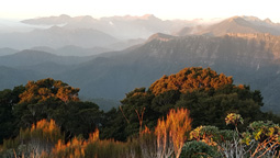
The scenery was quite different from the previous day. We were on the 'tops' and enjoyed the walk through alpine scrub and tussock lands with 360 views all around. Some of us decided to drop our packs and headed up to Croesus Knob (1204m). The route is rough and steep to the top and on a clear day the 360-degree views would be extensive (even as far as to Mt Cook and out to the Tasman sea). Our views were not so extensive and it was cold and windy at the top, but still worth the climb. It was from here we saw the first of the bikers riding across the tops. Most of the bikers we encountered were travelling straight through in one day.
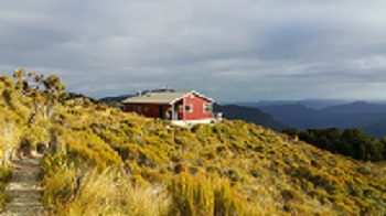
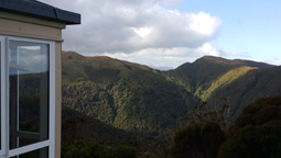
Arriving at Moonlight Hut was stunning. It has a fantastic location with magnificent views in every direction and the hut itself is well designed and appointed. (and there was internet coverage- and NZ won the America's Cup!). Soon after arriving the clouds rolled in - thick and grey- obscuring the views and the track heading towards the Pororari Hut.
Comments in the hut book at Moonlight Tops said it all. Often comments referred to wet, windy, foggy, cloudy and misty weather conditions but also clear, perfect, fantastic, sunny, fine, stunning - it just depends on the day! However, the comments serve as a good reminder that you do need to be prepared as this track does cover an alpine area and varied terrain.
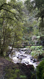
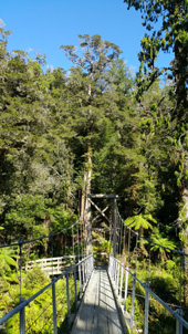
Both the Moonlight Hut and the Pororari Huts are of the same design. They have spacious porch rooms for boots and gear, 2 bunk rooms, lovely decks front and back, well appointed kitchens with plenty of tables and seating to spread out and scenic windows in every direction! The views continually changed as we spent our afternoon at the hut and it was possible to see the Pororari Hut (and the direction of tomorrow's walk along the escarpment) across in the distance.
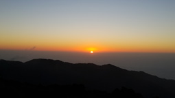
The sunset and evening sky was spectacular from Moonlight Tops Hut. It is well worth heading back up the track behind the hut and watching the sunset over the west coast sea.
Day three: Moonlight Hut to Pororari Hut (19.1kms.. 5-7 hrs)
Our biggest day on the track and I didn't want it to end- it was spectacular and there were so many photo opportunities!
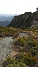
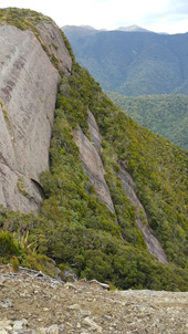
Walking first through alpine tussocks into very ancient beech forest with massive trees, then stunted alpine forest with all its shades of green followed by mixed podocarp forest. Sidling along the edge of the escarpment gave fantastic views in all directions. The cascading 'pillows' of rock faces were impressive and large enough to hold established forest trees in their folds- landscaping beautifully done by mother nature on a massive scale!
Having seen the Pororari Hut ahead for most of the walk it then seemed to take ages to finally get to it as we followed the ridge above Tindale Creek through the rainforest. Arriving at the Hut it was possible to look directly across to Moonlight Tops Hut and see where we had begun walking earlier in the day.
We enjoyed another stunning West Coast sunset from our high vantage point, over the Tasman sea and beautiful light on the rocky outcrops.
Day four: Pororari Hut to Punakaiki (16kms to Pororari River carpark)
We woke to a beautiful clear day and after more photos, headed down into the upper
Pororari River Valley. The track sidles the river gorge, through beech forest and rata which was still flowering. The scale of this gorge is massive and the way trees have managed to grow up its steep sizes is very impressive. We walked through forests of punga and forests of nikau. We continued onto the Pororari River Track and through its beautiful rainforest. The bikers follow a different route from here; first built during the 1860's gold rush. We continued walking alongside the Pororari River in its massive gorge and even braved a quick swim in the river- refreshing- before finishing at Pororari River valley.
The track finishes close to Punakaiki and the pancake rocks. It is worth taking a bit of extra time and having a look at this area as well- the West Coast surf is always impressive, as is the rock formations and extensive views along the coastline. A great finish to a varied and beautiful 4 days of walking. We were all extremely impressed with the quality of the track and facilities, (and the skill of those who have built it) along with the history and stunning scenery of the area, making this a great, Great Walk!
Weather Update Weather forecast for Nelson next 10 days.
What to take Ideas on what to pack for the tramp (My packing list!)
Existing & Budget trips If you want to combine on an existing trip.
[- Track Descriptions -]
Home Page | Existing Trips | Trampers Transport | Prices | Contact Us | Links Page